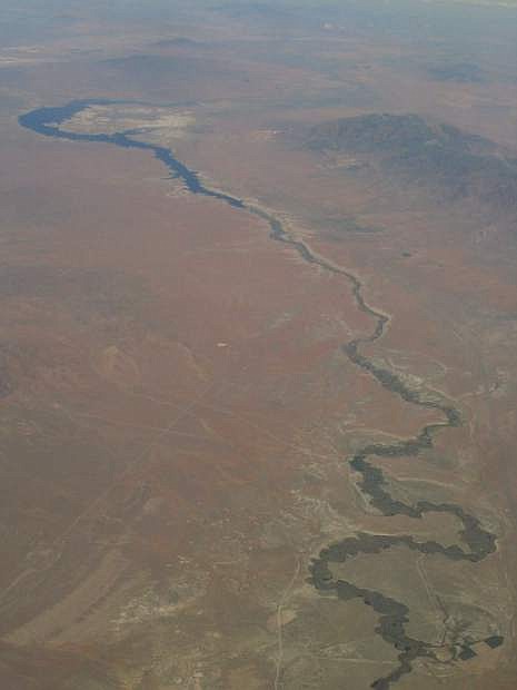
Aerial view of the Humboldt River, with all of its switchbacks and curves, near Rye Patch Reservoir.
In the mid- to late-19th century, the Humboldt River was cursed and condemned — often for good reason.
The river stretches some 300 miles, roughly, from above Wells in northeastern Nevada to the Humboldt Sink, southwest of Lovelock.
Pioneering white explorers, including Peter Skene Ogden and John C. Fremont, came upon this ribbon of water that winds across the width of modern-day Northern Nevada and thought it must be the legendary Buenaventura River, which they believed emptied into the Pacific Ocean.
The earliest maps of the region show such a river going deep into the interior country — a kind of St. Lawrence Seaway of the Pacific Northwest — which explorers were certain existed.
The mistake was easy to make. Most rivers flow from the interior of the country to an ocean, so the explorers assumed the Humboldt River probably headed west to the Pacific Ocean.
But the Humboldt, like the rest of the Great Basin’s rivers, was different. Like the Carson River, it flowed into a dry lake bed, called a sink. Indeed, Fremont named the region, the “Great Basin,” because of this unique interior drainage.
While the Buenaventura River myth was finally disproved, the Humboldt became the lifeline for the pioneering emigrants traveling to California. The fact it was just about the only water to be found between the Great Salt Lake and Pyramid Lake made it essential to making — and surviving — the journey.
But it’s incredibly wandering route (it’s been called the crookedest river in the world), its inconsistent flows and frequent poor water quality also made it the bane of the trip.
“Meanest and muddiest, filthiest stream, most cordially I hate you,” wrote one Iowa traveler in an 1850 poem, penned after surviving the trek along the Humboldt. And as if that wasn’t strong enough, he concluded with:
“Now fare thee well, we here shake hands
and part (I hope) to meet no more,
I’d rather die in happier lands than
longer live upon your shore.”
In his excellent book, “The Humboldt, Highroad of the West,” historian Dale Morgan noted: “This is the paradox of the Humboldt, that it was almost the most necessary river of America, and the most hated.”
The Humboldt also carried at least a half dozen different names in its formative years. Originally called “Unknown River,” it showed up on later maps as “Ogden’s River,” after his explorations in the region, then “Paul’s River,” after a trapper friend of Ogden’s and “Swampy River” (probably the most accurate of all the names).
Later, the name was changed to “Mary’s River,” after the wife of a Hudson Bay Company official and, still later, it was elevated to a higher plane of existence when the name somehow became known as “St. Mary’s River.”
Fremont, who attempted to name nearly everything he saw during his 1843-44 treks across the West, provided the final name, Humboldt River, in honor of Baron Alexander von Humboldt, another western explorer, who actually never saw the river.
The generally unfavorable press received by the river, however, did not prevent it from becoming a virtual highway to the West during the mid-19th century. Thousands of pioneers traveled parallel to the river on the route that became known as the Emigrant Trail.
Trading posts and communities began to appear in various places along its banks, including Humboldt Wells (now called “Wells”), Winnemucca, Elko and Lovelock. When the transcontinental railroad was finally built in the late 1860s, it followed a route almost parallel to the Emigrant Trail and the Humboldt.
Despite the improvements in travel, the Humboldt’s image was too ingrained for any type of redemption. In the 1860s, writer Mark Twain came upon the Humboldt and announced, “We tried to use the strong alkaline water of the Sink, but it would not answer. It was like drinking lye, and not weak lye, either.”
There are still places where you can see the Humboldt in its crooked, natural state. Probably the best spot is Button Point, a rest stop located about eight miles east of Winnemucca. Here, in the flat area to the north, you can see the twisting switchbacks and curves that made it so difficult to follow.
An historic marker at the rest stop also offers some background information on this most essential and frustrating of the West’s rivers.
Rich Moreno covers the places and people that make Nevada special.