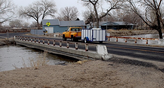
Water is running high at the Bafford Lane bridge northeast of Fallon.
Photo by Steve Ranson.
The Nevada Department of Transportation is monitoring one of the most vulnerable areas for flooding in Churchill County.
Meg Ragonese, NDOT’s public information officer in Carson City, said her agency is working with the Truckee Carson Irrigation District, Churchill County and other partners for any potential impacts to Bafford Lane.
Currently, water is running slightly under the bridge. Ragonese said Bafford Lane is a state-maintained road between U.S. 95 and the Carson River (basically, the west side of the river). East of the Carson River, she said, Bafford is a county-maintained road. Additionally, the Bafford Lane bridge is NDOT-owned.
During the flooding six years ago, she said NDOT, Churchill County and TCID cut sections of the Bafford Lane bridge and the riverbed embankment to allow increased flow of the Carson River as part of coordinated local flood mitigation measures.
Ragonese said NDOT is also monitoring the culverts under both U.S. Highways 95 south and 50 east.
In March 2017, Ragonese said NDOT added 12 six-foot by four-foot box drainage culverts to 10 roadway culverts already in place on U.S. 95 south of Fallon to help reinforce the highway against flooding when local partners release water from Lahontan Reservoir. About 860 feet of new box drainage culverts were installed to channel water underneath the highway when floodwaters are diverted from Lahontan Reservoir following heavy precipitation.
At this time, NDOT does not anticipate traffic or highway impacts from the drainage waters. Ragonese said improvements will also help reinforce the two federal highways against potential flooding in future years.
“NDOT will also closely monitor specific state roads and bridges in the area for any potential impacts of heavier water flows,” she added.
The U.S. Drought Monitor shows Churchill County split between severe and moderate drought. The eastern half of both Churchill and Pershing counties are moderate.
Churchill County’s Emergency Operations Center established on Monday a high-water call center. County spokeswoman Anne McMillin said the call center is a one-stop source of information during the current high-water emergency that could extend until early summer.
McMillin said the call center’s telephone number is 775-867-5923, and it will be staffed weekdays from 8 a.m. to 5 p.m.
“By calling this number, residents can get information on Lahontan Reservoir water levels, the availability of sandbags, county road closures, weather information, numbers to report river/canal or road blockages and if needed, evacuation and shelter information for people and livestock,” she said.
McMillin pointed out staffing hours and days may change to meet demand as the high-water season progresses.
McMillin is urging residents who live near a flood-prone area to consider flood insurance. For those living in the floodplain and carrying flood insurance, she said local officials urge residents to ensure their policies are up-to-date and active.
In one week, Lahontan Reservoir has added more than 20,000 acre-feet of water. The reservoir currently has more than 160,000 acre-feet.
Sandbag pickup (new hours)
Hours for picking up sandbags have been expanded. Sandbags may be picked up from 485 Miners Road at the following times:
Monday through Friday: 10 a.m. to noon and 12:30 p.m. to 2:30 p.m.
Saturdays and Sundays: 9 a.m. to 2 p.m.
Sandbag delivery available
For seniors and residents with mobility issues who live on the Carson River, McMillin said sandbag delivery is available by calling 775-867-5923.