A rendering from TSK Architects of Carson City’s new fire station and emergency operations center proposed for Butti Way.
Carson City personnel will be seeking a special use permit at Wednesday’s planning commission meeting for a new fire station and emergency operations center off Butti Way.
The meeting starts at 5 p.m. in the community center. Planning commissioners will consider a special use permit for an 18,077-square-foot building that would house a new fire station, emergency operations center and information technology offices. Parking spaces are part of the proposal as well.
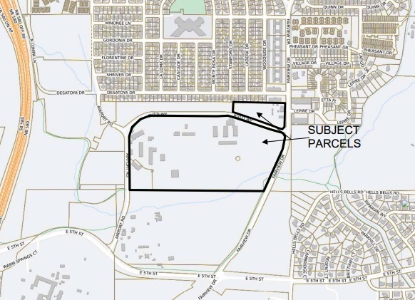
The project would affect two parcels zoned public regional.
“APN 010-031-04 is approximately 52 acres in size and is the site of the Carson City Public Works Corporate Yard,” reads a staff report. “The site includes office buildings for the Carson City Public Works Department and the Carson City Parks, Recreation and Open Space Department, storage and maintenance buildings.”
The other parcel, APN 010-037-02, is approximately 5.25 acres, according to staff.
“The site includes the Jump Around Carson offices and parking areas,” reads the report. “The new 18,077-square-foot-building and associated parking is proposed on APN 010-031-04. The building will be constructed of block and streel framing and will house a new fire station including two apparatus bays, crew rooms, restrooms, office space and a kitchen. The remainder of the building will house the Carson City Information Technology offices and the emergency operations center.”
According to staff, a minimum of 50 parking spaces would be provided on the facility site.
“This meets the required parking for the facility,” reads the report. “While not required to serve the new facility, additional parking is proposed across Butti Way, on APN 010-037-02, where the existing parking lot will be improved and expanded from 21 spaces to 46 spaces.”
In making the findings for the special use permit, as required by city code, planning staff said, “The proposed facility will result in better response time for the emergency services on the east side of the city.”
In the permit application, Public Works Senior Project Manager Darren Anderson said the new station could produce additional noise – the city’s fleet maintenance team already tests sirens at the site — but will improve emergency services.
“The new station will provide additional noise due to emergency responses initiated from the new facility; however, this location is fitting for this use and less impactful when compared to other locations on the east side of Carson due to the nature of the operations that occur in the (corporate) yard,” Anderson said. “The Carson City Fire Department Master Plan (2020) recommended adding two additional staffed stations to reduce travel time and improve effective response force coverage. This location helps meet this objective by providing a station in the eastern portion of town.”
In January, the Board of Supervisors approved using $2.4 million in American Rescue Plan Act funding for the new station. A total of $17.5 million has been allocated to the project, according to City Manager Nancy Paulson.
 Map from Carson City Community Development showing subject parcels for a new fire station and extra parking proposed for east Carson.
 In other action:
• Planning commissioners will consider several requests from Carson City stemming from the annual Master Plan review at the beginning of the year.
Commissioners are being asked to recommend to the Board of Supervisors a change in the Master Plan designation for roughly 73 acres located west of where Rhodes and Betts streets end. The request would change the master plan designation from low-density residential, mixed-use commercial and open space to low-density residential across the board. A concurrent zoning map amendment being considered would change the zoning on several parcels in the area from single-family 12,000 (minimum lot size), conservation reserve and limited industrial to single-family 21,000.
“Through the annual review of the Master Plan and zoning map, the board and staff have identified the subject parcels as appropriate for consideration of a mapping correction,” reads a staff report.
A separate request from the city would change the zoning on about 8 acres between Betts and Rhodes streets, just west of South Curry Street. Planning commissioners are being asked to make a recommendation to supervisors to change the zoning on several parcels from single-family 12,000 and limited industrial to multifamily apartment.
“The property has a Master Plan land-use designation of high-density residential, and this amendment would bring the site into conformance with the Master Plan land-use designation,” reads a staff report.