
Carson River near Buzzy’s Ranch in east Carson City in June 2023.
Photo by Scott Neuffer.
Carson City residents and visitors are being asked for their take on how best to use and protect the Carson River where it flows through the eastern reaches of the city.
A survey with more than two dozen questions will be online until Sept. 23 at www.carson.org/riversurvey.
“The survey will help guide the Parks, Recreation & Open Space Department in updating the Carson River Master Plan, originally published in 1996,” the city said in a news release. “Through the development of a community-driven master plan, Carson City seeks to manage, protect, interpret, and enhance the natural and recreational resources of the Carson River into the future.”
The survey asks for basic demographic information and when, where, how and why people use the river, from the trail system encompassing Mexican Dam and Morgan Mill to the rugged country of Carson River Canyon where the river eventually enters Lyon County. Recreational activities listed include hiking, fishing, off-highway vehicle use, photography and birdwatching.
And through the survey, the city hopes to gauge the relative safety people feel along the river and what they’re concerned about — issues like erosion, vandalism and pollution.
In June, the U.S. Environmental Protection Agency made a presentation to the Board of Supervisors regarding mercury contamination from historic mining along the river. Federal officials at the time said eating fish from the river in Carson City and downstream is a health risk, but recreational activities are otherwise safe.
“The big key theme, though, to note here is there are no major risks from recreational use of the land or water,” said Mohamed Ibrahim, a project manager from EPA’s Region 9. “That includes swimming and even incidental ingestion of the water if you’re swimming.”
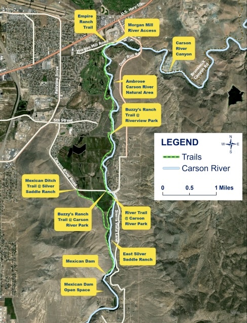
A trail map from Carson City showing routes along the river.
The link to the new survey takes those interested to a city webpage where the original Carson River Master Plan is available.
“The river loses 170 feet as it traverses Carson City, dropping from an elevation of 4,631 feet at the Douglas County line to approximately 4,460 feet where it enters Lyon County. One hundred and twenty feet of that drop occurs along a five-mile section of river in the Carson River Canyon,” reads a description in the original document.
The preface in the original plan states: “This master plan is intended to be a starting point and a document that guides the implementation of policy and development of improvement projects for the Carson River area. It is intended to be the vehicle that allows the community to move forward politically in order to address river related issues in the broadest sense.”
Lyndsey Boyer, Carson City open space manager, said the city has been working the Carson Water Subconservancy District and the National Park Service-Rivers, Trails, and Conservation Assistance program on the plan update, the latter organization providing technical assistance.
Boyer told the Appeal the first part of the update process is engaging the public and community stakeholders, including neighboring counties. She said adoption of the update could occur in late 2025.
Public stewardship of the Carson River has changed since the 1990s when the original plan was written. Through open-space acquisitions and public land transfers starting in 2008, Carson City now manages 11 miles of river corridor and 5,000 acres in the area, Boyer noted.
Why should people take the survey? Boyer said the city’s goal is to garner as much public participation as possible and to meet user needs.
“We want to make the river corridor beneficial to as many people, animals and everyone across the board as much as possible,” she said.