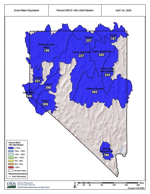
Map showing percentages of the median snow water equivalent for basins in Nevada and the Eastern Sierra.
Natural Resources Conservation Service
In addressing snow measurements taken on April Fools’ Day, the hydrologist for the Natural Resources Conservation Service in Nevada said he was only kind of joking about mountain recreationists having a hard time this summer.
“For recreationists, it means they’re not going to be hiking on ground until August,” Jeff Anderson told the Appeal on Monday. “It’s just a ton of snow, especially in the Carson and Walker (river) basins. They’re absolutely blowing away the old records.”
The numbers themselves tell the story. The Carson Basin was at 290 percent of the median snowpack on April 1. It’s the highest snowpack for the date since snowpack telemetry (SNOTEL) became operational in 1981.
Anderson pointed out many manually measured sites, which have been around longer, are seeing record levels as well. The measurement site at Blue Lakes, just west of the Carson River West Fork headwaters, set an April 1 record based on 105 years.
At 306 percent of median on April 1, the Walker River Basin further south has an even larger snowpack. Sonora Pass set a high for the date based on 89 years of records. The Tahoe Basin, meanwhile, is at 246 percent of median snowpack, the second highest for the basin since 1981. Marlette Lake, which sits above Carson City, set an April 1 record based on 105 years of data, Anderson said.
According to the U.S. Drought Monitor, updated March 28, much of the Sierra and western Nevada is out of drought, though different parts of Nevada and California remain in abnormally dry or moderate drought conditions.
Anderson said even with warmer weather, the snow will stick around due to the sheer amount of it. He used the example of the Mt. Rose summit site, where Monday there were 188 inches of snow, or 73.6 inches of water content. He said even at a high melt rate — which will depend on temperatures — the snowpack could take more than two months to liquefy.
“You’re just stretching the season really late,” he said.
Anderson said the Carson Basin is in a more “delicate” situation due to a lack of upstream storage. He pointed out flooding problems downstream in Churchill County and hoped the Carson River floodplain upstream would handle higher flows.
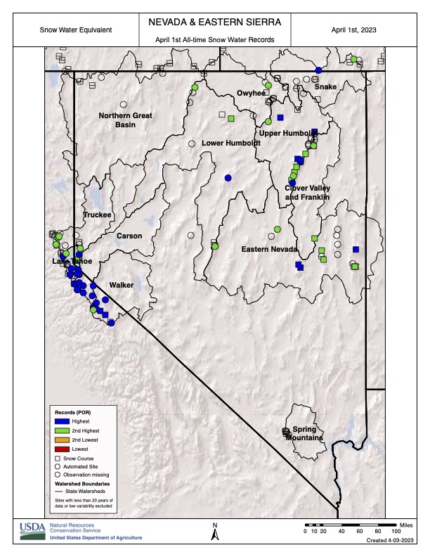 Map indicating measurement sites setting April 1 snowpack records this year.
 “As the climate warms, the atmosphere is warmer, and it holds more water vapor,” he said. “The last three winters we didn’t get storms. When we get the storms, they’re producing record-breaking amounts of snow when cold enough.”
Carson City Supervisor Stacey Giomi, who sits on the board of the Carson Water Subconservancy District, said he’s lived in the area since the mid 1970s and can’t remember a time when snow has remained on the ground in Carson as long as it has. He described the Carson landscape as a “bowl” in which snowmelt flows from the mountains to the river.
“I feel like we’re relatively safe in Carson,” he said. “We have the luxury of being higher up on the Carson River.”
He said while Fallon is already struggling with flooding, Carson streams should be able to handle the warm-season runoff.
“I think we could have some localized issues, but I really think we’re going to be OK as long as it’s a mild runup to this summer,” he said.
While Giomi called the snowpack incredible, he cautioned against taking one year’s data in isolation. More dry years could pull the region back into drought.
“That drought monitor changes quickly,” he said.

Comments
Use the comment form below to begin a discussion about this content.
Sign in to comment