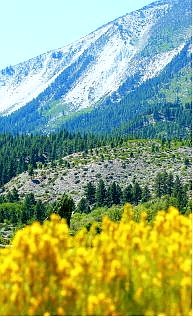
Rick Gunn/Nevada Appeal Slide Mountain shot from Washoe Valley.
Magma moving deep in the earth may have triggered a recent earthquake swarm near Lake Tahoe that caused Slide Mountain to grow slightly taller, according to a report released Thursday in the online version of the journal Science.
Between August and December 2003, approximately 1,600 earthquakes happened between Carnelian and Agate bays at Lake Tahoe, and are believed to have caused Slide Mountain located northeast of the lake to rise 1Ú2 inch in five months, the journal reported.
But that does not mean there's imminent danger of a volcanic eruption, according to the California Geological Survey. The magma is deep beneath the earth, somewhere between 20 to 30 miles, and there is no indication of a vent, which would be a sure sign of an active volcano, geologists say.
"This is a very interesting scientific discovery, but there's no cause for the public to be alarmed," said Michael Reichle, acting California state geologist
and head of the Geological Survey. "The most recent instances of magma reaching the surface in the Lake Tahoe area occurred about a million years ago."
Darryl Young, director of the California Department of Conservation, concurs.
"The chances of us seeing a volcanic eruption the Tahoe region in our lifetime are practically nil," Young said.
Research conducted by the Nevada Seismological Laboratory, Nevada Bureau of Mines and Geology, the California Institute of Technology and the Harvard-Smithsonian Center for Astrophysics showed the swarm of 1,600 tiny earthquakes coincided with the slight horizontal and vertical shift of a global-positioning system station on Slide Mountain, about 10 miles northeast of the swarm's center.
The earthquakes were usually below a magnitude of 2 and were not noticeable to people.
"They were very deep," Reichle said.
That information was shared with California Geological Survey, which tracks seismic activity in California, since most of the earthquakes occurred on the California side of the Lake Tahoe Basin.
"The finding is pretty exciting because it gives us a picture of what the earth is doing. It is the kind of thing that not too may years ago we would not have seen because we didn't have the instrumentation," Reichle said.
"With this new information, we'll be keeping a close eye on future seismic activity in the Tahoe area," Reichle said. "From a layman's point of view it takes a lot of energy to move that amount of mass and it happened all within that (five-month) window."
The swarm and other recent temblors are a reminder that residents of the Lake Tahoe-Reno region should prepare for future earthquakes, Reichle said.
"When someone says 'earthquake,' most people probably think of San Francisco or Los Angeles," Reichle said. "But there's an appreciable earthquake hazard in the Reno-Tahoe region, too, as well as other locations, such as Eureka and the Mojave Desert."
Nearly 90 earthquakes of magnitude 3 or larger have struck the Reno-Tahoe area since 1943. A 1966 magnitude 6.0 temblor in the Donner Pass area damaged the dome of state capitol in Carson City, cracked dams on the Truckee River and was felt as far away as San Francisco.
The largest known earthquake to strike the area was a magnitude 6.5 in 1887.

Comments
Use the comment form below to begin a discussion about this content.
Sign in to comment