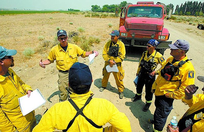
Shannon Litz/Appeal News Service Darren Swinney briefs a crew Tuesday from the Yerington Mason Valley Fire Department on the Jackass Flat fire and possible structure protection on Desert Creek Road. The fire, which started Monday, is burning seven miles south of Wellington near the Douglas and Lyon county line.
A fire captain for the Bureau of Land Management said firefighters were concentrating on structure protection as the stubborn Jackass fire continued to burn out of control.
By 7:30 p.m. Tuesday, the fire in a remote area seven miles south of Wellington had burned 6,200 acres of piñon, juniper and cheatgrass straddling the Douglas-Lyon county border.
Capt. Jim Farrell, coming off a 16-hour shift, said engines had been ordered for structure protection.
"So far, no structures are in immediate danger," he said.
Officials were concerned if the wind shifted, 10 to 15 homes on East Lane in Antelope Valley would be threatened.
The fire was one mile above the houses.
While no structures were lost by Tuesday evening, officials were concerned about a sage grouse nesting and breeding habitat.
Highways 338 and 208, which had closed temporarily, reopened Tuesday afternoon.
"The fire burned actively through the morning and afternoon hours, with sporadic spotting reported on those active fire fronts," said Tom Crawford, Sierra Front Information officer.
Thunderstorms predicted for the area posed threats ranging from flash flooding to difficulty in suppressing the fire due to erratic winds.
There was no indication when the fire would be contained or controlled.
"It's doing pretty much what we expected," said Mark Struble, Bureau of Land Management spokesman. "We're looking at record temperatures here in the valley, with slightly cooler temps, but not much, at the fire.
"The worst that could happen would be for a thunderstorm to park over top of the fire and for the winds to blow it out on all sides."
Travelers were advised to be aware of fire apparatus in the area and to drive slowly if smoke made visibility difficult.
Lynne Katusich, who lives in Antelope Valley, said she and her neighbors were in the "smoke center" rather than the fire zone.
"We're really socked in. I can't see the other side of the valley," she said. "It's weird, it's not the usual condition."
Katusich said she was on the opposite side of Antelope Valley from the fire, but was concerned for her neighbors across the way.
"I have a lot of friends over there and I'm worried," she said. "Fortunately for us over here, the lightning struck in Mills Canyon, but we got thunder bumpers enough to put out the fire above my house."
She said heavy winds Monday night blew the smoke out of the valley temporarily.
"It was like a gale force," she said. "My cat wouldn't even go outside. We get breezy nights, but not like that."
Katusich said she went to sleep, but awoke later to the smell of smoke,
"The wind had started whirling a bit and brining it back in," she said.
She said the Antelope Valley volunteer firefighters worked until 3 a.m. Tuesday and were back at the scene at noon shuttling water.
Mike Schiller watched the fire crest the hill Monday from his house on the south end of Topaz Lake.
"Ashes were coming out from everywhere and the wind was just roaring across the lake," Schiller said.
"It was dark early, then the whole hillside was engulfed in flames," he said. "I started taking pictures. By 11 p.m., it was over the top of the hill and by midnight it was gone."
Highway 338 was closed temporarily at the junction of State Route 208 north of Wellington. Desert Creek roads were closed to Highway 338.
Desert Creek Campground and other sites near Desert Creek were evacuated.
Crews from the U.S. Forest Service, Mono County, Lyon County, East Fork Fire and Paramedic Districts, the U.S. Marine Mountain Warfare Training Center, the U.S. Bureau of Land Management, Nevada Division of Forestry, Nevada Highway Patrol and Nevada Department of Transportation were on scene.
Resources included seven air tankers, two helicopters, one air attack observation plane, two water tenders, five dozers, four hand crews, 17 engines, five command staff and 120 personnel.
A Type I National Incident Management Team was ordered to take over the management of the fire and should be in place later today.
Jackass Flat fire
Estimated acreage
6,200
Location
-seven miles south of Wellington near the Douglas and Lyon county line
Threats
-Fire is about a mile from 10 to 15 homes on East Lane in Antelope Valley
-sage grouse habitat
Priority
structure protection
Air support
7 air tankers
2 helicopters
1 air attack observation plane
Ground support
2 water tenders
5 dozers
4 hand crews
17 engines
5 command staff
120 personnel
Responding units
U.S. Forest Service, Mono County, Lyon County, East Fork Fire and Paramedic Districts, the U.S. Marine Mountain Warfare Training Center, the U.S. Bureau of Land Management, Nevada Division of Forestry, Nevada Highway Patrol and Nevada Department of Transportation

Comments
Use the comment form below to begin a discussion about this content.
Sign in to comment