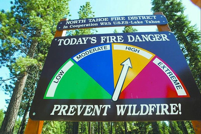
Ryan Salm/Sierra Sun Monitoring stations are placed throughout the Sierra Nevada. Measurements from these and various scientific methods are used to predict fire threat locally. This process is reflected on signs such as the one shown here.
Smokey Bear has been warning about the prevention of forest fires since the early 1940s. He often accompanies roadside fire danger signs posted at campgrounds, forests and national parks with reports ranging from low to extreme fire risks.
Every morning, below the radar of campers and hikers, the U.S. Forest Service evaluates the fire weather and the local fire station moves the sign's arrow to the appropriate danger level.
"Someone once said that all politics are local, but all fire danger is local, too," said Rex Norman, public affairs specialist with the Lake Tahoe Basin Management Unit.
Several local factors are combined at the fire weather stations to determine daily fire risk, Norman said, including relative humidity, wind, temperature and fuel moisture. The monitoring stations are located across the Sierra Nevada. Scientific methods and instruments are used to obtain the measurements.
The only other reason for changing the fire danger signs, Norman said, is for administration concerns like the Fourth of July holiday weekend. It is necessary to factor in potential fire risks associated with fireworks, though the risks according to fire weather may be only moderate.
The fire danger signs are important because they are a daily reminder to be cautious with fire.
"Basically, the intent is increasing public awareness as they enter in national forests - that added bit of precaution," said Steve Hook, fire prevention technician with the North Tahoe Fire Protection District.
South Carson Street drivers are reminded of the daily fire danger, those entering Kings Beach via Highway 267 or Tahoe City on Highway 89, are reminded that only they can prevent forest fires.
So you know
Color coordinating the risk:
GREEN = low
BLUE = moderate
YELLOW = high
RED = extreme
On the Net
www.smokeybear.com

Comments
Use the comment form below to begin a discussion about this content.
Sign in to comment