Jeff Moser/CourtesySome portions of the Tahoe Rim Trail are too difficult to ride over, especially on the ascent.
On July 24, a group of riders led by our guide, Marcus Marchegger, rode this adventurous 18 mile out-and-back from Kingsbury to Star Lake, a ride that has become one of my favorite sections of the Tahoe Rim Trail.
The Kingsbury Trailhead is a bit awkward and isn't as well marked as many of the other TRT trailheads due to the ski resort roads and buildings.
To get there, drive up to Dagget Pass, the summit of Kingsbury Grade. Take Tramway Drive south for about 1.5 miles to the Heavenly Valley Resort Stagecoach Lodge parking lot. There are no facilities here, however, there is a convenience store back on Tramway Drive if last-minute provisions are needed.
The trail begins underneath the Stagecoach chairlift at 7,400-foot elevation. This section of trail basically goes straight up the ski run, through a marshy area and then straight up through loose sand. Awful. We came back this way (still awful), but there is a better way to get going on the trail.
Ride back up the road you came in on, which parallels the ski run, turn right on the first switchback, and then make the first left on Needle Peak Road. Ride a short way back over to the ski run and around the gate. The road will become dirt, and ends up crossing the ski run where you rejoin the Tahoe Rim Trail. Look for the TRT sign at the trail that goes into the woods. This is where the real trail begins.
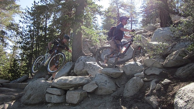
Once past the mileage sign, the trail begins with a series of switchbacks climbing through a forest of red firs and Jeffrey pine. The climb is moderate, but there are numerous boulders to navigate. The obstacles aren't huge, but enough to stop forward momentum. We had to dismount frequently to climb this section, but were able to ride most of it descending on the way back. After about a mile of climbing, we reached a saddle where the trail mellowed out and became relaxed rolling singletrack through the woods.
Western white pines and lodgepole pines become the dominant tree in this section. The trail crosses the south fork of Dagget Creek and goes under one of the ski lifts of Heavenly Ski Resort. The trail is wide and open in places, and other times it gets narrow as it goes through thick stands of manzanita and tobacco brush.
Eventually the trail arrives at the north rim of Mott Canyon where it meets a ski area service road. In one direction it climbs steeply up the hill, and in the other direction it dives down into Mott Canyon. For a rider accustomed to the gentle flowing grades of the Tahoe Rim Trail, neither direction looks inviting.
There is a small TRT sign high on the tree above that points the way down into Mott Canyon, but it's easy to miss since it is way above eye level.
Thankfully, Marcus knew the way, and we followed the steep sandy road down into the canyon. It wasn't far, but enough to make you worry that you were descending too much and think about how brutal it was going to be coming back up this road on the return trip.
Just when you think you've descended too far, the Tahoe Trim Trail takes off again to the south. Look for the little signs high up on the tree.
Soon the trail crosses under another ski area chairlift at the bottom of Mott Canyon. Numerous varieties of wildflowers grow along the tiny Mott Canyon Creek.
The climb out of Mott Canyon is breathtaking. Not so much for the scenery, but because of the big drop-off on the downside of the trail. It's a fun section, and keeps you focused. It's also a section where you can appreciate the hard work and engineering skills of the Tahoe Rim Trail trail builders.
Once out of the canyon, you begin the ascent to Monument Pass. The trail is reminiscent of the Flume Trail in this section, but instead of Lake Tahoe, you are high above the Carson Valley. This section is very exposed and becomes more difficult the closer you get to Monument Pass. We found ourselves getting off the bikes frequently to get over steps and get up the switchbacks. This was OK though, since it was nice to rest and enjoy the spectacular view.
At just over five miles into the ride you reach Monument Pass at 8,820 feet. You feel like you're pretty high up, but Monument Peak still towers above you to the west at 10,067 feet. This is a good spot to rest up from the climb you just did.
The trail is relaxing and rolling at this point, but a bit sandy. The fat tires on my big 29-inch wheels were really a plus for keeping the bike under control. It was great to get some continuous riding in after all the dismounting we did previously.
Before making the final ascent to Star Lake, we rode through a stand of very old juniper trees. Although the trees themselves weren't very tall, the trunks were massive. The bark looked and felt like it was several inches think, the inside of the tree impervious to the outside elements. Although not very tired, we really just wanted to spend time enjoying the company of these extraordinary trees.
Near the top of the final climb, I began to wonder just how far away Star Lake was. We came up on a trail marker, but it gave no distances. Before I could finish further speculation, we topped the ridge and there it was! The beautiful blue-green waters of Star Lake.
We had a nice long lunch at Star Lake. This is a place you'll want to spend some time. It's remote and unspoiled, a place that not many people get to see. Across the lake we could hear the whizzing reels of some fly fishermen, and farther down we could hear the occasional splash of people doing cannonballs into the water off some high rocks. Other than that, it was very peaceful. We soaked our legs in the cool waters and stared up in amazement at the craggy peak of Jobs Sister looming above us.
The return trip to Monument Pass was fantastic. After the fast descent out of Star Lake, the easy rolling terrain allowed a comfortable speed for looking around and enjoying the scenery. The wide open views make you feel on top of the world. I got the chills from the beauty and awesomeness.
Another thing that is worth mentioning about this ride is all the different micro-environments you pass through. As you descend out of Star Lake, you pass through stands of western white pine, lodgepole and hemlock.
Soon after, you ride through giant juniper trees. Climbing back to Monument Pass there are sagebrush and mountain mahogany, giving it more of a desert feel. The scenery is always changing, and keeps the trail interesting.
After climbing to Monument Pass, we began our descent down to the Carson Valley side. Much of the trail that we had to walk up on the way out was now rideable with gravity on our side. There are some big granite boulders to pick your way through in the beginning, and then fun staircases to bounce down after that.
Some of the switchbacks were still too tight to navigate though, and we had to dismount occasionally. Once the trail smoothed out, we enjoyed a scenic ride along the cliff above Carson Valley, then back down the narrow path to Mott Canyon where we rested.
At the sandy road climb, Troy made a granny gear attempt to scratch his way up the hill, but the rest of us pushed our bikes up. It took seconds to descend this thing, but several minutes to get back up.
Once back up on the north rim of Mott Canyon, we were treated to a long smooth singletrack section, relaxed and rhythmic. Lots of twists and turns and fun trail features to ride over. We came to the final saddle, and finished off the last mile of switchbacks down the hill. Again, we were able to ride much more of the trail than we did when we were ascending.
We ended the ride with the steep sandy trail down the ski slope back to the parking lot. Again, this is not the best designed section of the trail, especially when compared to the construction marvels of the trail up above, but it was probably better than coming back down the pavement section we had climbed in the beginning.

Comments
Use the comment form below to begin a discussion about this content.
Sign in to comment