Twenty-eight years ago, Life Magazine said U.S. 50 across Nevada was the “Loneliest Road in America.”
According to Life, the 287-mile stretch of road between Fernley and Ely was remote, had few points of interest, and urged travelers to have “survival skills” to make the journey.
In response, the communities along the route—Ely, Eureka, Austin, Fallon and Fernley—worked with the Nevada Commission on Tourism to develop a tongue-in-cheek “Highway 50 Survival Kit” containing brochures and maps detailing places on the highway.
Additionally, a game was created that urged travelers to stop in each of the communities to have a special Highway 50 map stamped by a local business or Chamber of Commerce. The validated maps could be redeemed for an official “Loneliest Road Survivor” certificate, a pin and other souvenirs.
Over the years, the promotion has been a big success and each year journalists and tourists drive the road so they can claim they’ve survived the Loneliest Road in America.
The Nevada Tourism Commission has also continued to hand out the “Official Highway 50 Survival Guide,” which challenges travelers to “take the trip across Nevada’s heartland, stop in the five largest towns to get your Official Highway 50 Survival Guide validated and discover it for yourself. If you dare.”
The guide includes information about communities and points of interest along the highway, such as Sand Mountain, the Old Shoe Tree, Stokes Castle and Great Basin National Park.
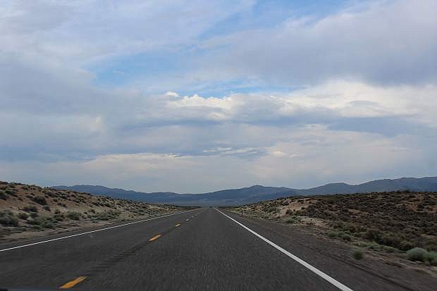
So is Highway 50 that lonely? Not really. According to the Nevada Department of Transportation, it’s not even in the top ten when it comes to lonely roads in the state.
It is, however, an extremely beautiful and scenic route that roughly follows the historic Pony Express and Overland Stagecoach trails (you can still find ruins of old stations along the way) and passes through a couple of the best 19th century mining towns in Central Nevada, such as Eureka and Austin.
Starting in Fernley, which is actually on Alternate Highway 50, the road passes through some alkali flats and the hamlet of Hazen before it reaches Fallon. Travelers can also begin the journey via Dayton, one of the state’s oldest and most historic communities, which is right on U.S. between Carson City and Fallon.
Often called Nevada’s “breadbasket,” Fallon is famous for its Hearts of Gold cantaloupes, which are celebrated each Labor Day weekend at the Hearts O’ Gold Cantaloupe Festival.
Fallon’s Churchill County Museum is one of the finest rural museums in the state. The museum’s exhibits include several describing the hardships of traveling across Nevada by covered wagon.
About fifteen miles from Fallon is Grimes Point, which contains prehistoric petroglyphs. An interpretive trail leads through the rock writings. Nearby is Hidden Cave, an archeological site that has yielded important artifacts that tell the story of Nevada’s earliest inhabitants. The cave is open to guided tours scheduled through the Churchill County Museum in Fallon.
A few more miles east is Sand Mountain, an unusual 600-foot-high mountain of sand that stretches over two miles. Wind-blown sand from the bottom of a prehistoric sea that once covered Nevada created the giant dune, which is a popular recreation spot for off-road vehicles.
Adjacent to the mountain is the site of the Sand Mountain Pony Express Station, which has been partially restored.
The next stop is Austin, another former mining town that claims three of the loveliest frontier churches in the West, several cemeteries and a number of historic structures and ruins.
Another hour or so of driving leads into Eureka, perhaps the best-preserved example of a 19th century mining town in the state. The town is a great place to explore, with its beautifully restored historic buildings, including the Eureka Sentinel newspaper building, now a museum.
Continue another 77 miles east to Ely, once a thriving copper mining town and home of the Nevada Northern Railway, one of the best-preserved shortline railroads in the country. Excursion trips on the vintage train are offered during the year.
While Ely is technically the end of the official “Loneliest Road,” a worthwhile continuation is to keep driving east for another hour and a half on U.S. 50 to Great Basin National Park. While there, be sure to take a tour of Lehman Caves and leave enough time to hike to the groves of ancient bristlecone pine trees in the park.
For a copy of the “Official Highway 50 Survival Guide,” go to http://ponyexpressnevada.com/highway50/index.html.
Rich Moreno covers the places and people that make Nevada special.

Comments
Use the comment form below to begin a discussion about this content.
Sign in to comment