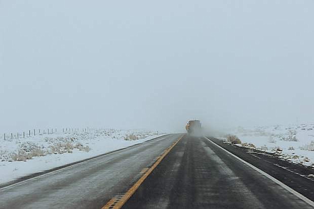
January borrowed a page out of the March storyline and roared out of the Lahontan Valley like a lion.
From Friday night to late Sunday, the National Weather Service in Reno reports that between 6 to 9 inches of snow fell in Churchill and Northern Lyon counties.
NWS Meteorologist Scott McGuire said it will take some time for the weather service to review snowfall records for the rural areas, but he said Sunday’s total in Reno was a record for that date.
“The snowfalls varied,” McGuire said for Fallon and Fernley. “We had reports of 6-7 inches, some 8-9 inches and a few 9-inch reports.”
McGuire said the Tonopah Low, an upper cold low pressure system that forms in central Nevada, affected areas across the northern tier of the state with strong winds and precipitation.
“The Tonopah low brought high-end snowfall,” McGuire said.
The latest storm resulted in 9.1 billion gallons of water running into Lake Tahoe. McGuire said the lake is within 11 inches of its natural rim. He said flows of local rivers have picked up as well thus resulting in Lahontan Reservoir receiving 613 million gallons of water to raise its level by 4,000 acre feet to 25,833 as of Tuesday.
“This storm was a fantastic event and a real impact for the farmers. We do need a few more storms,” McGuire added.
Any significant storms within the next 10 days are not on the radar, however.
Except for several weak systems coming through this week, McGuire said a high ridge of pressure is forming over the region and will quiet the storms. He said the high ridge is setting up along the West Coast.
The weak disturbance is expected either late Wednesday or Thursday and will bring a 20 percent chance of rain or snow. The weekend is shaping up to be good with partly cloudy skies and highs returning to the upper 40s and lower 50s. Morning lows will hover in the 20s.
McGuire said the NWS computerized readings of key points around western Nevada still look good. He said the Lake Tahoe basin snowpack is 135 percent of normal, and river flows also look good. McGuire said the Truckee River’s flow is 114 percent of normal, followed by the Carson River at 126 percent and Walker River at 119 percent.
The second snow survey of the season at the Mt. Rose SNOTEL site shows the snowpack is 125 percent of normal. In January, more than 50 inches of snow fell at the site to bring the total depth to 104 inches.
The weekend snowfall caused Churchill and Lyon counties to delay the start of school by two hours on Monday. Meanwhile, the Fallon Police Department did not report any significant problems on city streets, but the Churchill County Sheriff’s Office handled seven crashes including two single-car rollovers on the Schurz Highway on Saturday and a single-vehicle crash on Wildes Road.
Sheriff Ben Trotter said deputies responded to four incidences during the weekend to include a hit-and-run on the Reno Highway and Lucas Road.
“A gray Ford Explorer heading east crossed the median and began sliding toward the victim’s vehicle, a black Kia driven by Glenn Van Valkenburg of Reno,” Trotter said.
Based on reports, Trotter said the occupants of the Kia were not transported to a medical facility.
The Nevada Highway Patrol reported three crashes in Churchill County over the weekend, all occurring on U.S. Highway 95 south between mile markers 6 and 11. Trooper Duncan Dauber, a spokesman with Northern Command West, said the incidences included two property crashes and one injury crash.
Dauber said the injury crash had four occupants who all sustained claimed injuries. He said no one was transported to any local hospitals.
NHP troopers, though, were kept busy with several vehicles that had skidded off the area’s highways or motorists who needed assistance.
Troopers also attended to two people on Monday when their vehicle rolled over on U.S. Highway 95 south of the landfill.

Comments
Use the comment form below to begin a discussion about this content.
Sign in to comment