With dramatic limestone and sandstone cliffs, Red Rock Canyon National Conservation Area, near Las Vegas, is one of Southern Nevada’s most scenic locales.
In fact, the first thing you notice about Red Rock Canyon is its color. The cliffs are layered in rich, colored bands of red, gray and yellow—the result of a geologic process known as “thrust faulting.”
Sixty-five million years ago, sheets of rock were pushed upward and twisted in such a way that the older rock formations made of limestone were pushed on top of the newer sandstone rock.
Red Rock is one of the few places in the world where this type of faulting can be found.
The 197,349-acre Red Rock Canyon National Conservation Area, which is administered by the Bureau of Land Management, also contains 19 marked and developed trails (http://www.redrockcanyonlv.org/lasvegas/hikes-trails/).
Plan to wear sun screen (as well as a hat) and pack plenty of water since temperatures can be extremely hot, particularly in summer.
The Red Rock Canyon Visitor Center is located near the entrance of a 13-mile, one-way scenic drive that passes trailheads for most of the hikes. Maps and instructions for the entire area can be obtained at the visitor center or can be viewed at: www.redrockcanyonlv.org/wp-content/uploads/2012/09/Red-Rock-Trail-Map.pdf.
One of the easiest walks is the three-quarters of a mile hike along Lost Creek. The trail begins about 7.5 miles from the visitor center via the scenic drive. After parking in a marked area, you can begin walking beside Lost Creek, a trickling permanent stream.
The trail passes beautiful sandstone cliffs before ending in a box canyon with no outlet that during the spring contains a pleasant waterfall.
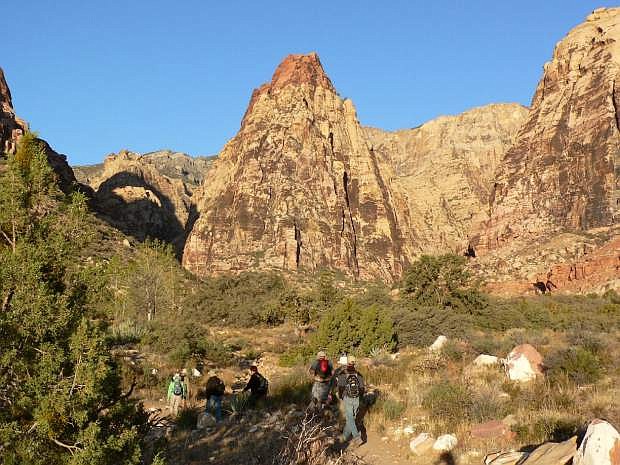
Another worthwhile hike is the three-mile (roundtrip) walk along Pine Creek Trail, which is accessed from the Pine Creek Canyon Overlook, located about 10.5 miles from the visitor center.
From the trailhead, the route slants downward to join a closed dirt road that leads to the ruins of the Horace Wilson homestead (a pioneer family in the area). Above the abandoned ranch site, where only foundations remain, the road splits, and you should go left.
Soon the trail enters a small stand of large ponderosa pine trees, which give the trail its name. Ponderosa pines are rarely at this elevation in the desert—they normally live in much higher and moister climates.
You also pass spiky agave plants, juniper, and the ubiquitous sagebrush. The trail winds through sandstone walls that are streaked with black desert varnish before it ends in the rocks near a stream bed (it will have water most of the year).
You can continue hiking for another mile by following the stream’s path deeper into the canyon.
For a different perspective, the three-mile (roundtrip) Keystone Thrust Trail offers an opportunity to study the unique geological events that helped create Red Rock Canyon.
The trailhead is located at the lower White Rock Spring parking area. From the parking lot, follow a dirt road for nearly a half-mile. Turn right (east) on another dirt road and continue for three-quarters of a mile to a fork. Follow the right branch into a small canyon that leads to the Keystone Thrust Fault.
At the fault, you can clearly see the fracturing and upthrusting that make Red Rock Canyon so geologically fascinating. The trail offers spectacular views of the surrounding area, but the lack of trees means there is no shade.
The presence of water and vegetation in Red Rock supports a large number of animal species. Sometimes, with binoculars and a bit of luck, you can spot bighorn sheep, bobcats, gray foxes and even wild burros at the higher elevations.
For more information about Red Rock Canyon National Conservation Area go to: http://www.redrockcanyonlv.org/. There is a $7 per vehicle fee.
Rich Moreno covers the places and people that make Nevada special.

Comments
Use the comment form below to begin a discussion about this content.
Sign in to comment