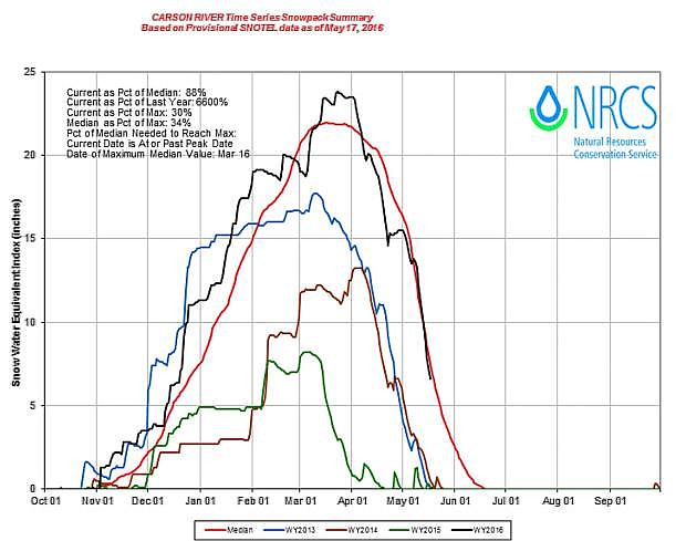
Carson River time series snowpack summary
The second community meeting to discuss flood mitigation efforts in the Lahontan Valley is Monday at 7 p.m. at the Churchill County Commission Chambers, 155 N. Taylor St.
Members of the county’s emergency management team will update residents on the current status for potential flooding in Churchill County
Before Monday, though, much of western Nevada will endure a roller-coaster ride of unpredictable spring weather that will bring cooler temperature and rain to the Lahontan Valley.
After several days of upper 80-degree temperatures and clear skies, the forecast makes a 180-degree turn by bringing rain and temperatures in the 60s.
The California Nevada River Forecast Center predicts the Carson River will rise to 4,300 cubic feet per second at Fort Churchill by Monday but then drop by almost 1,000 cfs on Tuesday.
Ernie Schank, president of the Truckee-Carson Irrigation District Board of Directors, said the forecast in the higher elevations indicates an early May storm arrives this weekend with cooling along the Sierra Crest.
“Next week along the Sierra Crest looks like some chance of precipitation each day as a series of quick-moving storms passes through,” Schank advised the emergency management board.
The National Weather Service’s indefinite flood advisory for the Carson River through Churchill County remains in effect for areas near the riverbank.
NWS Meteorologist Scott McGuire said he visited Fallon on Wednesday to see the situation and flood mitigation work.
“You guys have done a good job getting the word out about the snowmelt,” he said. “Things are being handled well out there. It’s been impressive, and they (TCID) have been proactive in controlling the flows. Everything looks like its performing as it should.”
McGuire also said the May 1 readings of the Sierra snowpack by the Natural Resources Conservation Service show nearly unprecedented snow-depth records for this time of year.
McGuire said the Lake Tahoe Basin is 380 percent of normal, while the Truckee Basin is at 261 percent and the Carson Basin at 379 percent. He said the percentages of the basin index, which measures the snow water equivalent, remain high because of elevation and lateness in the season for having such a deep snowpack.

Comments
Use the comment form below to begin a discussion about this content.
Sign in to comment