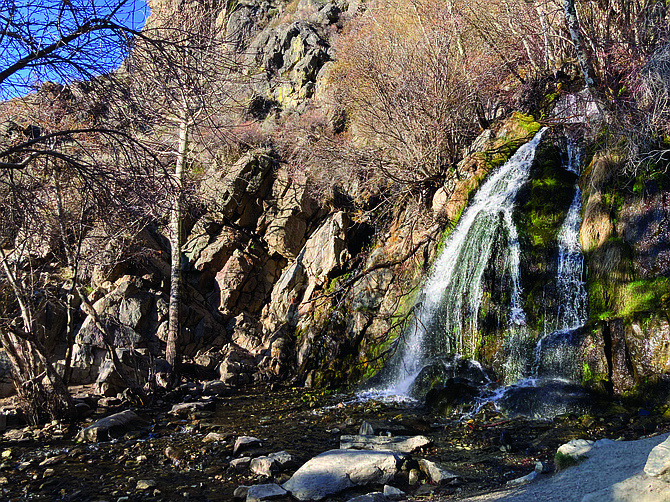
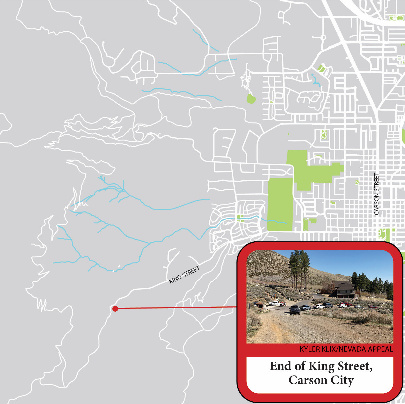
Kings Canyon is well known in Carson City nowadays and attracts dozens of visitors daily. With the snow melting off the mountains, the creek is flowing. If you go this time of year not only will you see a rushing 25-foot waterfall, but you’ll also see spring blooming with wildflowers, butterflies and birds. It’s a beautiful place where the desert turns into the wooded mountains at the base of the eastern Sierra Nevada. This is a popular spot and can get a bit crowded. Be respectful of others and don’t leave trash or any sign that you were there. Be considerate of the homeowners nearby and drive the speed limit. There is talk of a project to revamp the parking lot to include bathrooms and more. Read about the last discussion here: bit.ly/3ap1NcT. Besides the short waterfall trail, there are two longer trails: the short loop (2.2 miles) and the long loop (4.4 miles). Get to the trailhead parking lot by driving west of downtown on King Street, which ends at a dead end. WATERFALL You’re lucky if you get a moment alone here. The waterfall is 0.3 miles from the parking lot with 140 feet of elevation gain, making it 0.6 miles round-trip. The 25-foot cascade flows year-round, and it is raging in the spring. The dirt path climbs gradually up a switchback. It’s not difficult for most people to walk this short section. If you’re able to scramble up the rocks, there are a few more small cascades to see. SHORT LOOP If you already started on the path toward the waterfall, the short loop continues from there. Long switchbacks carved into the hill bring you about 452 feet higher than the parking lot. You’ll have an expansive view of Carson City from here and the backside of C-Hill. Once you climb as high as you’ll go, the trail cuts into the canyon on a narrow path to the stream that feeds the waterfall. There’s a small footbridge; plenty of bamboo and other plants you’ll find closer to water. Just beyond here, the path connects to an older road at an intersection. Turn toward the right (east) to follow the path back down the hill to the where you parked. The road from this point is well taken care of, so it is easy to walk on, compared to many old roads with large rocks exposed. If you were to turn left here and go uphill (west), the road is not maintained with more rugged terrain. You can climb this loop from either direction. LONG LOOP The Long loop goes deeper into Kings Canyon and takes you more than twice as high as the short loop, with about 1,020 feet of elevation gain. There are some great views along the way and another waterfall to see where the landscape changes into forest. Coming from the south end of the trail, the beginning follows an OHV road that is part of the Lincoln Memorial Highway. From the parking lot, you head up the rugged road toward the south. These 1.3 miles of the trip is rocky, being an old road. There is a kiosk marking where the trail veers from the road. It takes 1.7 miles from that kiosk to get to the smaller waterfall. This part of the trek follows an easy dirt path. There are lots of trees around with several species of birds flying between them all. There will be wildflowers if you’re here the right time of the year. From the top you can see a portion of Washoe Lake. The path continues going up with several switchbacks, and then you reach the waterfall. This waterfall is much narrower, and it’s not easy to get near. There is a bridge and just beyond that is an intersection. One path continues toward Ash Canyon, which would take about 6.4 miles to get to the end of that trail. There will be signs clearly marking the ways, but turn right to go downhill. From here it is 1.3 miles back to the parking area. This part of the trail once again follows an older road, so it’s steeper and rockier. Going up this way is more difficult, so it is recommended to start from the south. Kyler Klix is a designer for Nevada News Group. He also writes about the outdoors and entertainment. Email him at kklix@nevadanewsgroup.com.