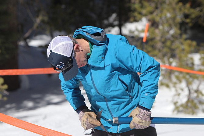
Hydrologist Bill Anderson of the Natural Resources Conservation Service checks the bottom of a cylinder for snow and dirt before weighing the content.
Photo by Steve Ranson.
MOUNT ROSE SUMMIT — Southeast of the Mount Rose summit, equipment nestled in deep snow offers daily reports on the snowpack and water content not only at this remote location but across the Sierra Nevada and other mountain ranges in the Silver State.
Nevada is one of many western states that uses this method of measurement to keep a tab on the winter conditions that pound the many mountain ranges from Alaska to states east of the Continental Divide.
On the first Monday of the month from January to April, Jeff Anderson, a hydrologist with the National Resources Conservation Services, representatives from other agencies and the media strap on snowshoes and descend to a site more than 400 yards from the highway to learn more about the most up-to-date figures on water content.
For western Nevada’s ranchers and farmers who receive their water from the region’s tributaries, the amount of water that flows from the mountains to the streams and then in the Truckee, Carson and Walker rivers will indicate if it’s a good or bad growing season.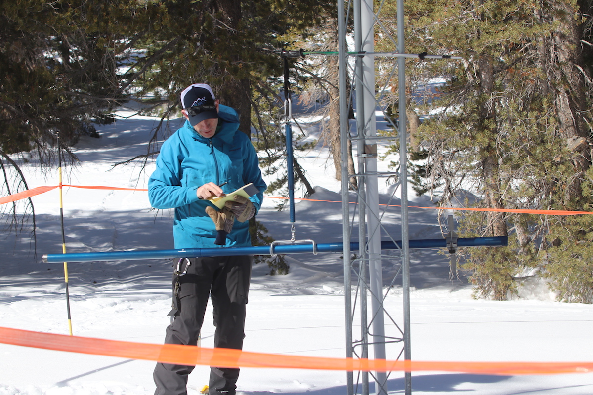 Steve Ranson / LVN
Bill Anderson, a hydrologist with the Natural Resources Conservation Service, manually figures the snowpack and water content at the Mount Rose Summit SNOTEL.
SNOTEL READINGS
Anderson said the Monday’s figures show the SNOTEL (Snow Telemetry) site near the summit has recorded a total 68-inches of snow with 21 inches of water content. That amounts to 65% of median for this first day of March. He said since February 1, this station gained only 3 inches of water content, a fact that left Anderson concerned.
“Normally, we would gain only 9 inches, only a third of what we have,” he said.
The Carson region is at 73% of median, and the Walker Basin is the lowest of the four reading with 63% of median peak. This, he said, represents the 15th lowest snowpack out of the past 41 years. Meanwhile in northeastern Nevada, the current snow water equivalent ranges from 83-94% of normal in the Upper Humboldt and 107% in the Lower Humboldt Basin. The Upper Humboldt includes the Owyhee River and Clover Valley southeast of Wells. In northwestern Nevada, the Northern Great Basin stands at 97%.
Across the region, Anderson said about 85 SNOTELS — 50 positioned across Nevada and 35 in the eastern Sierra — electronically records precipitation and water content each hour based on the weight of snow placed on a fluid-filled bladder. He said each basin has about eight SNOTEL sites, most of them located at different elevations.
“A lot of them (SNOTEL) sites are located on the divide so we can use them for both basins,” he said, specifically referring to the Truckee and Carson basins.
His visit to the Mount Rose site each month allows him to weigh the snow content manually and then validate the electronic readings to ensure accuracy. Despite the low number, he said weathermen and hydrologists have seen miracles to replenish the water downstream.
“In 2020, February almost had no snow, not the kind of month we wanted,” he pointed out.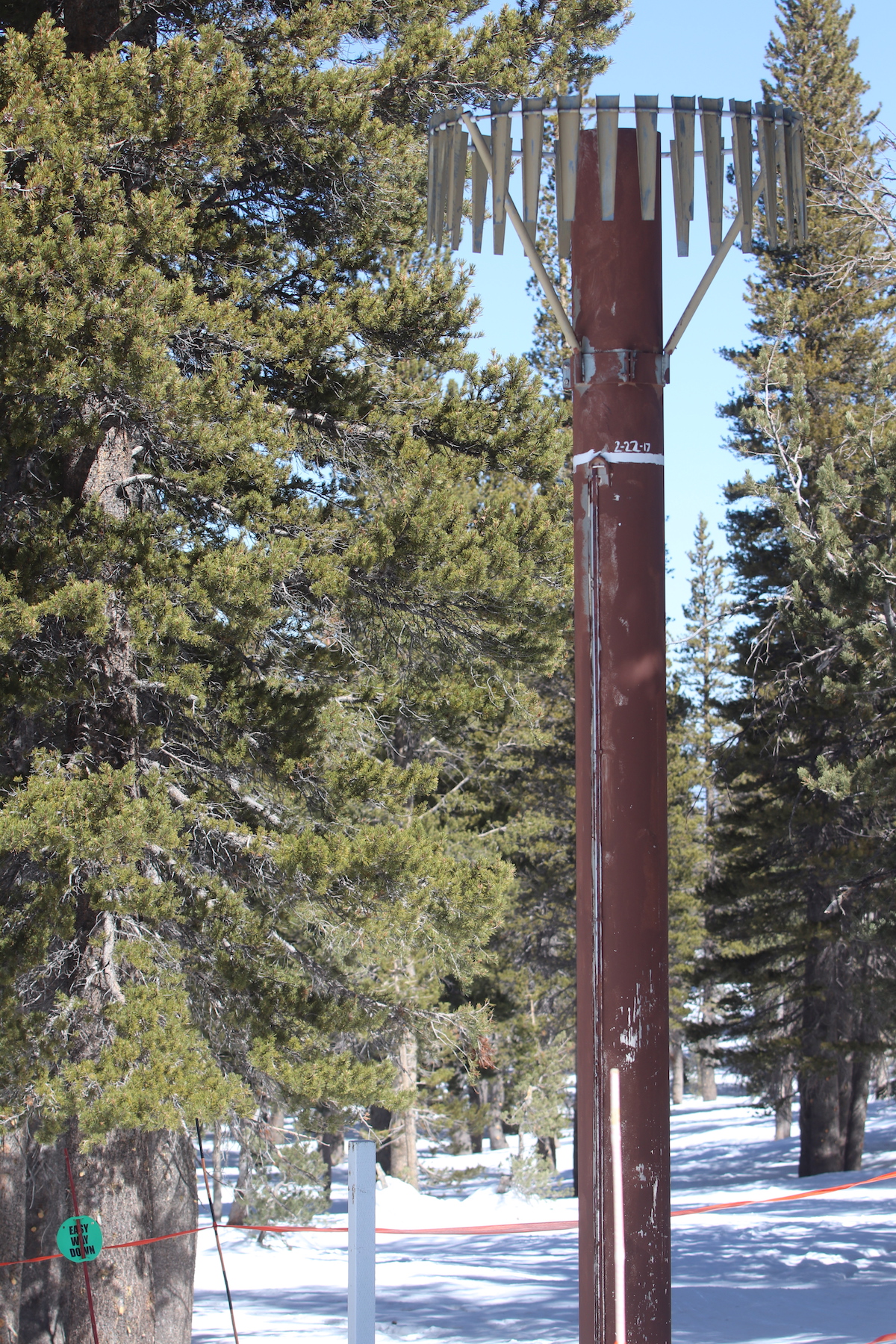 Steve Ranson / LVN
A white circular marker show the snow depth at the SNOTEL site on February 22, 2017.
MARCH MIRACLE
Then the March miracle occurred when storms battered the Sierra into mid-April.
“We had a really good comeback,” Anderson said, sounding more like a college basketball coach guiding his players in the Sweet 16.
Anderson said the short-term forecast for the upcoming weeks, however, does not look promising. He said storms could slam into the Sierra later this month, and that would wrap up, what he called, a Miracle March, by increasing the snowpack and water content. Thirty years ago, the Lake Tahoe basin recorded a March precipitation of 257% of average, and last year was 192% of average from mid-March to April 7. If the Truckee Basin doesn’t receive more snow, Anderson said the SNOTEL site would record only 60% of median.
“We really do want to see those storms come in,” Anderson said.
Based on historical data, though, Anderson said there’s only a 10-20% chance that snowpacks will push the percentages to normal by April 1.
Area ranchers like Lester de Braga, whose family has lived in the Stillwater District east of Fallon for more than 100 years, appreciates the information provided by the NRCS. Predicting snowfall across Nevada for Anderson may be just a tricky as trading on the stock market. One year may set records, while the following year causes consternation for the water users such as de Braga.
“It’s pretty important to go by,” de Braga said of the SNOTEL readings. “We don’t have any other factors.” Steve Ranson / LVN
On March 1, the amount of snow near the Mountain Rose Summit SNOTEL site represents the 15th lowest snowpack out of the past 41 years.
During the water season, de Braga, who is also secretary of the Truckee Carson Irrigation District Board of Directors, said both the Bureau of Reclamation and district work together to determine the storage level of Lahontan Reservoir based on the amount of potential water coming downriver. Like Anderson, de Braga and the other users are optimistic that the big storms will occur in March and April.
During the fall, de Braga begins to plan crops for the following year and hopes there’s enough water. Yet, he’s a realistic knowing he and other can’t control the storms.
“We’re at their mercy,” he said, knowing the water season will be either fantastic or a disappointment.
BAD AND GOOD YEARS
Andersons said the last bad water year was 2015 when a low snowpack stretched across the Sierra. He said during early spring of that year, he walked over a patch of the Sierra to the Lake Tahoe shore. Instead of trudging through snow, he was walking on dirt. From records of very little snowpack and water content to the record years, Anderson said the Sierra totals in 2017 and 2019 provided him and others with a wealth of information.
Anderson said records were set four years ago for the amount of water content that roared down into the rivers from the Sierra Nevada. Both the Carson and Truckee rivers saw rising water levels as did sections of the Walker River. TCID and Churchill County constructed an emergency weir and spillway to send excess water from the V-line Canal into the desert. The water eventually flowed under a federal highway toward Carson Lake and to the Stillwater National Refuge via a manmade 60-foot wide, 15-foot deep channel. At the time, predictions indicated the Sierra Nevada contained enough water content to fill three Lahontan reservoirs.
A precipitation gage at the Mount Rose SNOTEL shows how deep the snow measured on Feb. 22, 2017.
“The gage is 25-feet tall, and we had over 20 feet of snow here in February of that year,” Anderson said, pointing toward the circular mark. “We’re well behind that.”
Two years later also set records.
“We didn’t set records high, but at 7,000-8,000 feet, we set records with mid-elevation snow,” he said.
With warmer water coming in another month, though, Anderson said it’s best for the snow to melt rapidly, which will force more water into the rivers and eventually to the reservoirs.
WATER ALLOCATIONS
The TCID directors and General Manager Rusty Jardine met Tuesday to look at both the current water situation and allocations for growers. The latest readings from the NRCS and future forecasts were also reviewed to determine allocations. Water orders in the Lahontan Valley begin March 15 with deliveries on or after March 22.
The U.S. Drought Monitor stills shows most of the Great Basin in a severe drought category. Voicing Anderson’s concerns, Jardine said he has his fingers crossed for more storms. Under the Truckee River Operating Agreement, TCID will also receive about 14,000 acre-feet of water storage.Currently, Lahontan Reservoir is over 108,000 acre-feet or about a third of capacity. One acre-foot equals about 326,000 gallons, or enough water to cover an acre of land. Lahontan Reservoir holds 308,000 acre feet.
Anderson said he doesn’t expect the Lahontan Reservoir or Lake Tahoe to fill up, but Jardine, nevertheless, expects a decent water year.
“We’re looking at 90% allocation from the Carson and 100% allocation from the Truckee,” he said.